LAS VEGAS — A street food market coming to The Strip this summer will put on display dishes made with recipes imported straight from Asia’s bustling culinary scene.
Famous Foods Street Eats will open at Resorts World Las Vegas in late June or early July and offer guests a wide selection of authentic cuisines from Singapore, Malaysia, Thailand and beyond.
Inspired by the hawker-style food centers of Singapore, this 24,000-square-foot hall will have dishes at 16 stalls from top chefs and restaurateurs.
Here’s a look at the stalls guests can expect when Resorts World opens:
The traditional Hainanese chicken rice at Boon Tong Kee.Courtesy Resorts World
Ah Chun: Traditional Chinese Shandong dumplings and hand-pulled noodles. Au Chun won a Michelin Guide’s Bib Gourmand award from 2013 to 2021.
Boon Tong Kee: Traditional Hainanese chicken rice — poached chicken paired with rice cooked in chicken broth — based on recipes from Singapore’s Chinatown in 1979.
FUHU Shack: A western reinterpretation of one of China’s most alluring dishes — Peking duck burritos.
Geylang Claypot Rice serves Southeast Asian rice dishes cooked in traditional claypots.Courtesy Geylang
Geylang Claypot Rice: Southeast Asian rice dishes slowly cooked in traditional claypots with recipes that started over four decades ago in Singapore. This eatery won a Michelin Plate in 2016.
Googgle Man’s Char Kuey Teow: Rice and egg noodles fried with fresh seafood on a charcoal-fired stove to produce a smoky aroma called “wok hei” –or “dragon’s breath.” Singapore’s Chef Ah Guan — also known as “Googgle Man” — must wear goggles while cooking to protect his eyes from the intense heat.
Pepita’s Kitchen: A stall from Dedet de la Fuente, also known as the “Lechon Diva.” This Manila chef is known for her stuffed lechon — or roasted pig.
Springleaf Prata Place: A family-style concept from Singapore serving cuisine from South India. Staples include Chicken Curry and Teh Tarik — a frothy, hot milk tea popular in Singapore.
The braised beef noodle soup at Ten Sun.
Ten Suns Braised Beef: Thai beef noodle soup from a legendary family shop located in Bangkok Old Town. This eatery won a Bib Gourmand from the Michelin Guide in 2019, 2020 and 2021.
Tiger Sugar: Known for Black Sugar Boba Milk, this Taiwanese bubble tea shop features a menu of cold black tea varieties.
Dessert: An array of pre-packaged sweets from around the world, including gourmet cookies and treats.
Mamak: A word that translates to a sundry store in Singapore, Mamak sells snacks and keepsakes, including take-home food kits, books and souvenirs.
The Crispy Bird sandwich at Streetbird.Samuelsson Group
Streetbird Las Vegas: A winner of the James Beard Award, thisChef Marcus Samuelsson’s take on one of America’s favorite comfort foods — fried chicken. This menu includes Sweet & Spicy Fried Chicken, Hot Honey Chicken & Waffle, Wild Wild Wings and Mac ‘n Greens.
Luru Kuru Pa Yakitori: A Japanese and anime-inspired concept from Grammy artist and DJ Steve Aoki that serves a variety of yakitori, kushiyaki and yaki onigiri as well as signature drinks and mochi.
Mozz Bar: An Italian food counter from James Beard Award finalist James Trees, this spot serves up mozzarella and burrata, fresh baked bread, small bites and sandwiches — including favorites like chicken and eggplant parmesan.
The Blood Bros. BBQ platter. White Beard Photography
Blood Bros BBQ: This acclaimed Houston spot specializes in classic Texas barbecue, but this time there will be a Chinese and Vietnamese twist.
Nori Bar: A sushi stop for made-to-order handrolls, sashimi, warm seasoned rice, chilled seafood and nori with an accompanying menu of sake, matcha green tea, seasonal teas and draft Japanese beer.
Famous Foods Center Bar: This 16-seat center bar features a self-pour and automated beer system that cycles through a rotating selection of beers from around the world. Wine and cocktails are also on tap here.
Here Kitty Kitty Vice Den: A grunge-style speakeasy serving craft mixed drinks.
A Humboldt Park man faces an attempted murder charge after allegedly shooting a man earlier this year in the West Side neighborhood.
Travoy Johnson, 25, shot a man while intervening in a fight between the man and a woman Jan. 25 in the 1000 block of North Ridgeway Avenue, Chicago police said.
The man, 31, was struck in the shin about 6:15 p.m. and took himself to Saint Mary’s and Elizabeth Medical Center in good condition, police said.
Police arrested Johnson Monday in the 800 block of North Hamlin Avenue after identifying him as the shooter, police said.
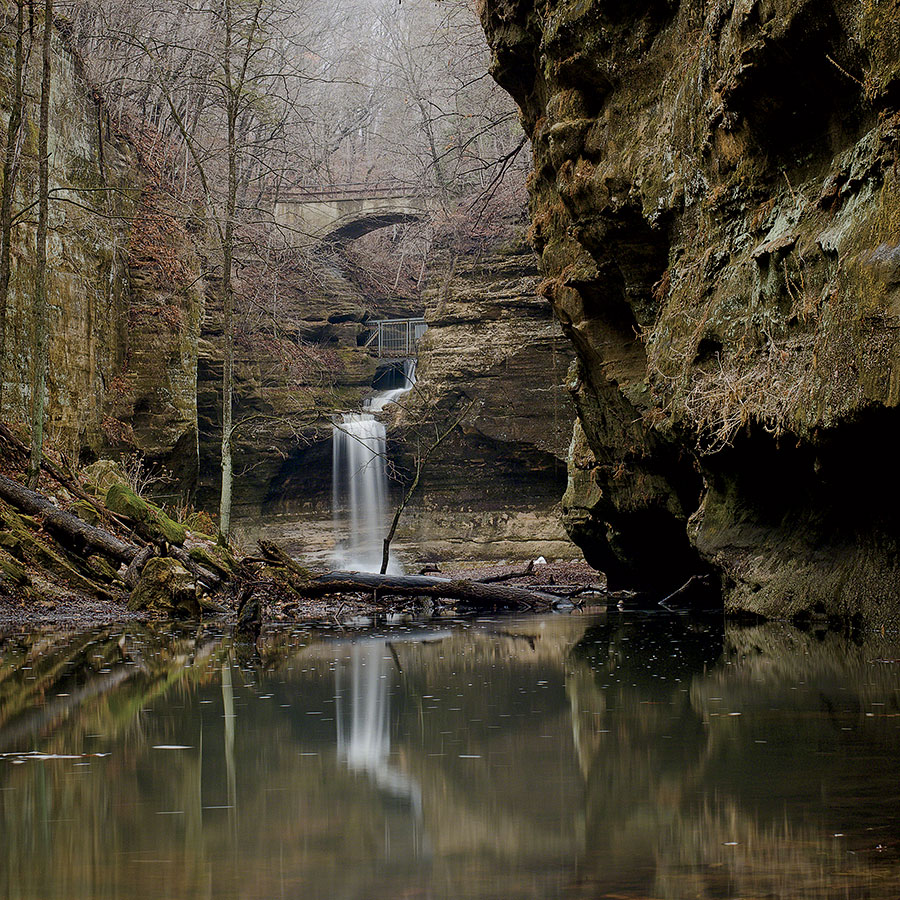
Summer may be peak season at this crown jewel of Illinois parks, but its legendary canyons, bluffs, and trails are arguably at their most appealing between March and May, when snowmelt and spring rains feed Starved Rock’s stunning waterfalls. Follow the trails marked in green to the falls at French, Wildcat, LaSalle, Ottawa, Kaskaskia, Illinois, Aurora, and St. Louis Canyons. The sandstone formations, carved millennia ago by glacial forces, make for eye-popping scenery in their own right — and are best admired from the trail, because climbing the notoriously crumbly rock is ill advised. Or tackle the Starved Rock and Sandstone Point Overlook Trail, a four-mile loop, rated moderate in difficulty, that offers a commanding view of the Illinois River. The park’s name comes from the death by starvation of a band of Illiniwek seeking refuge on a butte here during a battle over the death of Ottawa chief Pontiac in the 1760s — a solemn reminder of whose land you’re hiking through and the privilege of communing with it. Look for Bald eagles. The Plum Island Eagle Sanctuary, which occupies a 45-acre island in the Illinois River opposite the park’s visitor center, is a wintering area for the birds. In spring and summer, you’ll have a chance of seeing a mating pair that are permanent residents. While there Reward your exertions with a pint at the Lone Buffalo, a taproom in nearby Ottawa operated by Tangled Roots Brewing Company.
Photograph: Allison Cisneros/USDA Forest Service
Communing With Illinois’s Original Landscape
MIDEWIN NATIONAL TALLGRASS PRAIRIE Northeastern Illinois
Drive time About an hour
Bison, the prairie’s once-abundant original inhabitants, were reintroduced in 2015 as part of a conservation initiative at this 18,500-acre preserve, which occupies the site of a former ammunition plant and is the first federal tallgrass prairie in the country. You can’t walk among the bison — currently the herd numbers around 50 — since they roam in pastures fenced off from the park’s 33 miles of trails, but sightings are common. Years of painstaking restoration of the area’s tallgrass habitat has resulted in an unparalleled variety of birdlife. Keep your eyes out for sandhill cranes, black-necked stilts, dickcissels, Henslow’s sparrows, and the rare black-billed cuckoo. Created in 1996 and considered one of the most significant conservation triumphs of the 20th century, Midewin offers a chance to experience the natural prairie that covered much of the Midwest but is now all but obliterated. Look for A prehistoric glacial erratic. Follow the Henslow Trail to where it crosses Route 53 to see this 19-ton boulder that was pushed south by an ice sheet, possibly from as far as present-day Wisconsin. While there The nearby village of Elwood boasts a rare attraction: a paved section of the original Route 66 — America’s Mother Road — that you can actually drive on. (It’s on what’s now Douglas Street.)
Photograph: Illinois Office of Tourism
Breathtaking Views of America’s Mightiest River
MISSISSIPPI PALISADES STATE PARK Northwestern Illinois
Drive time Just under 3 hours
The riverbank bluffs, or palisades, that are the centerpiece of these 2,500 acres make for exhilarating hiking and gorgeous panoramas. Fifteen miles of relatively short, interconnected trails ascend the bluffs and plummet into cool, fern-filled ravines, offering views of erosion-carved limestone formations with names like Indian Head and Twin Sisters. But you don’t have to scramble to earn your views: Several paved paths lead to platformed overlooks that take in the confluence of the Mighty Miss and the Apple River. Have an old-fashioned picnic in one of the shelters built in the 1930s by the Civilian Conservation Corps. In spring and summer, look for the colorful splendor of brightly blooming lobelias and bluebells. Look for Woodland mammals. Weasels, muskrats, and badgers make their home here. While there The historic downtown of nearby Mount Carroll has rightly earned a spot on the National Register of Historic Places. It features brick-paved streets and remarkably well-preserved 19th-century Victorian houses.
Photograph: Redman Thundersnow/Forest Preserves of Cook County
A Birding Bonanza Less Than an Hour From Downtown
PALOS PRESERVES Southwestern Cook County
Drive time 45 minutes
This 12,000-acre complex of trails and protected lands — constituting the largest forest preserve system in Cook County — is about as remote-feeling as you can get without leaving the metro area. The Yellow Trail is an eight-mile gravel loop that offers a decidedly away-from-it-all vibe and traverses the Cap Sauers Holding Nature Preserve, the largest roadless area in the county. Bring binoculars: Bald eagle sightings are common, and the preserve hosts an exceptional variety of less glorified birds, including summer tanagers, eastern phoebes, pileated woodpeckers, and Louisiana waterthrushes. Seeking a workout? Enter the Swallow Cliff Woods off Calumet Sag Road and sprint up the limestone stairs leading to the top of a 100-foot bluff. Worried about getting lost in all that wide-open space? Relax: Virtually all Cook County Forest Preserve trail maps are accessible on your phone. Look for Baby wood ducks falling from the sky. The waterfowl nest in tree cavities, says Cook County Forest Preserves ecologist Kristin Pink, and the babies will occasionally plummet out and scamper toward water. While there Make the day an action double-header by also hitting the Forge: Lemont Quarries, a new adventure park eight miles away featuring aerial rope courses, laser tag, and more.
Photograph: Erik Lykins/Getty Images
Cliffs, Bluffs, and Dells Without the Crowds
MATTHIESSEN STATE PARK North-central Illinois
Drive time 2 hours
This 4,500-acre expanse of woods, canyons, glens, and creeks possesses virtually all the natural beauty of Starved Rock — the bigger and better-known state park just a few miles to its north — minus the throngs of nature-deprived city folk. Situated along the Vermilion River near its junction with the Illinois, Matthiessen has a less extensive trail system than Starved Rock’s (just five miles of groomed paths), but those trails traverse remarkably variegated terrain and can take you deep into the park’s signature wooded valleys, or dells. Watch for white-tailed deer along the trails, some of which cross the rushing creeks that empty into the Vermilion and sluice over the dells’ terraced rocks in sprightly cascades. Sorry, no swimming, no matter what you’ve seen on TikTok. Look for Winsome yellow lady’s slipper orchids (a.k.a. moccasin flowers). They flourish in the nature area bordering the dells. While there What’s better than a blood orange margarita after a vigorous hike? One accompanied by some light shopping for handcrafted jewelry, teas, scarves, and soaps. The Ottawa wine bar Cat’s Eye and its gift boutique, A Mess of Things, offer both.
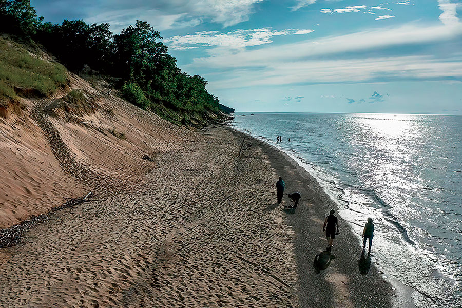
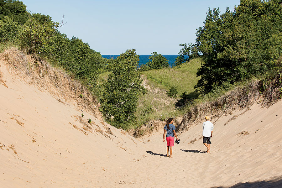
Encompassing rivers, woodlands, prairies, wetlands, and, of course, the eponymous hills of sand, Indiana Dunes National Park is one of the most ecologically diverse preserves in the nation. With 14 trail systems totaling more than 50 miles, the park is as welcoming to visitors seeking a little birdwatching as it is to those intent on an all-day trek. “You’ve got incredible natural features that aren’t found anywhere other than the south end of Lake Michigan, including oak forests that grow right out of the sand,” says hiking advocate Jay Readey. A great introduction is the 4.7-mile Cowles Bog Trail, which takes in oak savanna, ponds, marshes, swamps, and beaches, as is the justifiably popular Dunes Succession Trail, which rewards hikers who scramble to the top of the dunes with gorgeous lake views sheltered by fragrant jack pines. Look for The distant Chicago skyline. Seen from the tranquil heights of the dunes, it’s one of the most memorable views of the city you’ll ever have. While there Grab a burger at Industrial Revolution Eatery & Grille in Valparaiso, 20 minutes due south, and make a night of it by catching a movie at the 49er Drive-in Theatre, open April through October.
Photograph: Jeremy Iushewitz
An Unsung Woodland Gem
SEVEN BRIDGES IN GRANT PARK Southeastern Wisconsin
Drive time 1 hour 30 minutes
An invitation by Romantic poet William Cullen Bryant beckons at the entrance of this easily overlooked county park south of Milwaukee: “Enter this wild wood and view the haunts of nature.” Inscribed on a covered wooden bridge, the words offer a fitting welcome to this beguiling expanse of deeply shaded ravines and stone paths that abuts an intimate Lake Michigan swimming beach. Flanked by trout lilies and trilliums, the trail weaves through birch, maple, and white ash trees and leads to steep stone staircases, nooks with benches for resting, and those seven footbridges — creating an enchanted-forest vibe that kids will dig. Keen observers crossing another of the bridges will notice a second Bryant verse, one that captures the appeal of the place: “May the God-given peace of this leafy solitude rest upon and abide with thee.” Look for The distinctive limestone pavers on the trail. Those and the ones forming the retaining walls came from the nearby Lannon stone quarry, which produces a pretty dolomite used to clad countless buildings in the area since the 1850s. While there In Milwaukee, just 10 minutes north, pick up a dry-brined rotisserie chicken from the beloved bistro Goodkind or sip a cortado on the patio of Colectivo Coffee.
Photograph: WIWoods/Getty Images
A Journey Into the Ice Age
KETTLE MORAINE STATE FOREST, SOUTHERN UNIT Southern Wisconsin
Drive time About 2 hours
When the ice sheet that covered much of North America retreated some 12,000 years ago, it left a distinctive landscape of hills, kettles (surface depressions), ridges, and lakes across a great swath of what is now Wisconsin. Those natural features take pride of place on any stretch of this 23,000-acre forest’s 100-plus miles of trails. A good option for glacially minded first-time visitors is hiking the segment of the 1,000-mile Ice Age National Scenic Trail that cuts through a particularly gorgeous stretch of the park. You’ll see ancient sedimentary formations such as kames (gravel or sand mounds) and eskers (long, winding ridges) and, if you’re observant, plenty of flora and fauna too: The park is home to red foxes, turkeys, and coyotes and an abundance of wildflowers, including forked aster, yellow gentian, and eastern prairie fringed orchid. Families and dog owners can tackle any of the loops in the Nordic Trail system, which extends across gently rolling terrain traversing pine and hardwood forest and open plains. Look for The ruins of an old resort. Complete with a still-active artesian spring and trout pond, it rises alongside the half-mile loop trail Paradise Springs. While there Venture to the nearby mill town of Whitewater for a farm-to-table meal at the Black Sheep, which sources from nearly a dozen local farms and fisheries.
Photograph: Naga Film/Getty Images
A Riverside Ramble
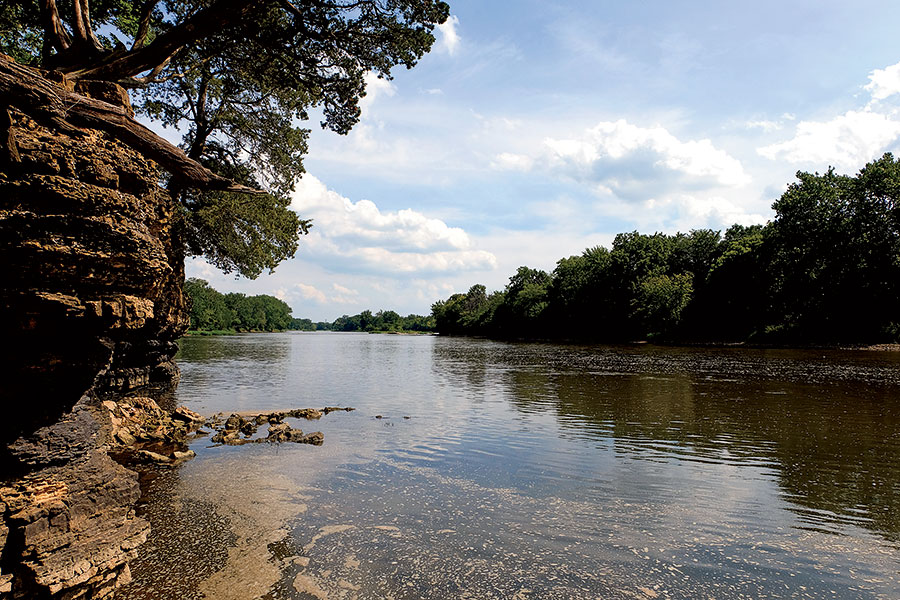
KANKAKEE RIVER STATE PARK Northeastern Illinois
Drive time About an hour
A mostly flat, woods-shaded trail forms the backbone of this 4,000-acre park hugging both banks of the river. Hardcore hikers might call the 10.5-mile paved and gravel route more of a walk than a hike, but for parents with stroller-age kids, it’s a chance to plunge into a distinctive natural habitat without having to put the kid in a carrier. A three-mile spur along Rock Creek, a tributary, leads to limestone canyons and a waterfall. That creek is rated as one of the cleanest streams in Illinois, and the naturally channeled Kankakee was recently ranked No. 1 for water quality in the state by the Illinois River Watch Network. All the more reason to bring your fishing gear: Smallmouth bass, channel catfish, northern pike, and walleye abound. Look for The grave of Potawatomi chief Shaw-waw-nas-see. The trail running alongside Rock Creek leads to a boulder that marks it. While there Scuba diving in Illinois? You bet. Nearby Haigh Quarry is a spring-fed, limestone-lined lake that’s been turned into a diving refuge.
Photograph: Joshua Nowicki/Southwestern Michigan Tourist Council
Hidden Lakes and Pristine Dunes
GRAND MERE STATE PARK Southwestern Michigan
Drive time 1 hour 30 minutes
This 985-acre jewel hugging Lake Michigan’s eastern shore harbors a tranquil dunes habitat and three ancient inland glacial lakes called, prosaically, North, Middle, and South. A handicapped-accessible paved trail departs from the picnic shelter; a half mile in, the pavement gives way to a sandy footpath that forks right toward a mile-long beach backed by dunes, and left toward South Lake, which is nestled in an undeveloped natural preserve that’s home to waterfowl and songbirds. Beach-bound hikers can summit Baldtop, a 760-foot dune, before sprinting (or tumbling) toward the crystal waters of Lake Michigan. The National Park Service has named Grand Mere a National Natural Landmark, owing to its unique terrain and ecological diversity. Look for The geological phenomenon known as aquatic succession. This transformation of glacial lakes into terrestrial habitat is happening right before your eyes with the three interdunal lakes. (Two other lakes beyond the park have already turned into bog forest.) While there Southwest Michigan’s Makers Trail features more than 45 breweries, cideries, wineries, and distilleries within 25 miles of the park. Try a barrel-aged cider at Peat’s Cider Social, just across the road from the park.
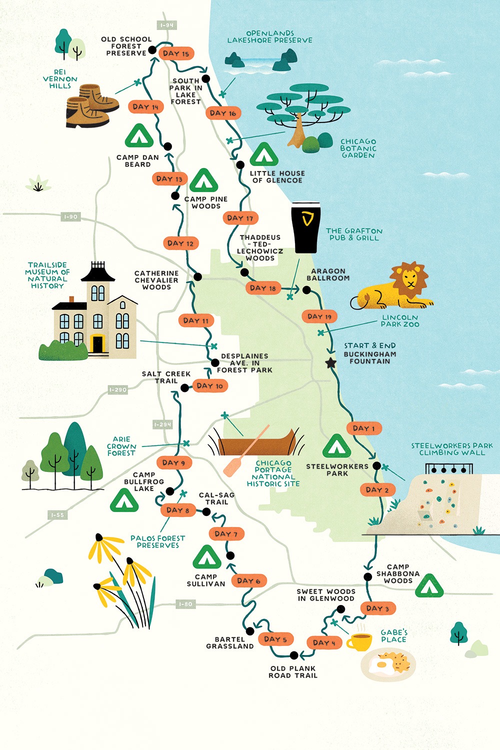
Beginning and ending in Grant Park, the Outerbelt extends as far south as Tinley Park and as far north as Libertyville, connecting many of the county forest preserves that surround the city. The length of each day’s hike on this suggested itinerary ranges from five to 15 miles. More ambitious hikers can tackle the loop in less time. Others can choose to complete it over the course of many months, or just hike a portion of it on a day trip. For a detailed, interactive map of the route and other suggested attractions and campsites, visit www.outerbelt.org.
Day 1
Buckingham Fountain → Steelworkers Park Miles 12 Check out Steelworkers Park Climbing Wall (a 30-foot climbing and bouldering wall on a remnant of a massive former steel mill)
Day 2
Steelworkers Park → Camp Shabbona Woods, Miles 15
Day 3
Camp Shabbona Woods → Sweet Woods in Glenwood Miles 11
Day 4
Sweet Woods in Glenwood → Old Plank Road Trail Miles 11 Check out Gabe’s Place (for an old-school diner breakfast)
Day 5
Old Plank Road Trail → Bartel Grassland Miles 9 Check out Bartel Grassland (585 acres of former farmland restored to bird- and wildflower-filled native prairie)
Day 6
Bartel Grassland → Camp Sullivan Miles 13
Day 7
Camp Sullivan → Cal-Sag Trail Miles 10
Day 8
Cal-Sag Trail → Camp Bullfrog Lake Miles 10 Check out Palos Forest Preserves (birds and wildflowers galore)
Day 9
Camp Bullfrog Lake → Salt Creek Trail Miles 12 Check out Arie Crown Forest (sheltered picnic groves and three miles of woodland trails)
Day 10
Salt Creek Trail → DesPlaines Avenue in Forest Park Miles 10
Day 11
DesPlaines Avenue in Forest Park → Catherine Chevalier Woods Miles 10 Check out Trailside Museum of Natural History (nature displays in a Victorian mansion)
Day 12
Catherine Chevalier Woods → Camp Pine Woods Miles 11
Day 13
Camp Pine Woods → Camp Dan Beard Miles 6
Day 14
Camp Dan Beard → Old School Forest Preserve Miles 12 Check out REI Vernon Hills (to buy that rain parka you forgot to pack)
Day 15
Old School Forest Preserve → South Park in Lake Forest Miles 10
Day 16
South Park in Lake Forest → Little House of Glencoe Miles 8 Check out Openland Lakeshore Preserve (pristine beach and bluffs)
Day 17
Little House of Glencoe → Thaddeus “Ted” Lechowicz Woods Miles 12
Day 18
Thaddeus “Ted” Lechowicz Woods → Aragon Ballroom Miles 10 Check out The Grafton Pub (for a perfectly poured imperial pint of Guinness)
Day 19
Aragon Ballroom → Buckingham Fountain Miles 10 Check out Lincoln Park Zoo (commune with your favorite animals before the home stretch)
Source: Chicago Outerbelt Alliance; daily mileage is approximate
The Chicago Blackhawks are officially eliminated from playoff contention. It was always going to be the Tampa Bay Lightning, Florida Panthers, and Carolina Hurricanes occupying the top three spots in the division in any order but the fourth spot was up for grabs all season. The Hawks were the favorites to hang onto that spot with a few weeks left in the season but they blew it. It was honestly a good thing because it stopped fooling people into thinking this was actually a good roster.
ChicagoBlackhawks fans should be livid at the way things are with this team right now.
Stan Bowman actually had people fooled at the beginning of the season. He was really strong at this year’s trade deadline but that was about the only thing he’s been good at for a long time now. This team was overachieving by a lot when they looked like a playoff team early. They are not loaded with talent like they once were. Patrick Kane and Alex DeBrincat were great but the depth was certainly challenged.
Some people might really like a few of the young players but they are not what you think. They aren’t at the same level as some of the young players that came up with the team in the late 2000s. There are a few nice pieces to build around like Kirby Dach and Ian Mitchell but there is a lot more they need.
Management should be ashamed of themselves for allowing it to happen. At the same time, the Hawks are what we thought they were. We went into the season knowing it was one of the worst rosters in the league. Jeremy Colliton did a good job getting them to buy in for a while but eventually, the Dallas Stars and Nashville Predators allowed their talent to take over.
There need to be some changes to this team. Stan Bowman’s departure is long overdue but we will see if they actually do something about it. They need a full-blown rebuild and have committed to that but there is no telling if they will actually do it.
People don’t want to admit that letting someone like Patrick Kane get traded is the right move at this point but they won’t realize it until it’s too late. For now, they need to play out the rest of the season and go from there. The players and coaches deserve some credit because they worked so hard with so little. Everyone else should be embarrassed, including the fans.
ONE HUNDRED YEARS ago this spring, a group of British explorers and Sherpa guides took the first steps toward the summit of Mount Everest, the highest peak in the world. Clad in tweed and gabardine and armed with rudimentary climbing gear, the group set out to prove the possibility of reaching the top of a mountain Sherpas call Chomolungma, or “Goddess, Mother of the World.”
Over the course of six months, members of the Mount Everest reconnaissance expedition, which included a 34-year-old English climber and schoolteacher named George Mallory, explored multiple approaches to the summit and photographed and sketched vast areas of the region around the mountain. Thirty-two years later, building upon the knowledge and experience gathered on those early treks, New Zealand climber Edmund Hillary and Sherpa Tenzing Norgay became the first humans to reach the Roof of the World.
In celebration of that initial exploratory expedition, we spoke with dozens of the world’s top climbers, climate scientists, physicians, gear makers and high-altitude climbing experts to examine 20 questions we’ve answered in 100 years on Everest and how exploration of the world’s highest peak looks different today.
So how tall is this mountain, anyway?
Then: In 1856, 65 years before the British reconnaissance expedition, the Great Trigonometrical Survey, commissioned by the British government, determined the summit of Mount Everest, then known simply as Peak XV, to be 29,002 feet tall and the highest peak above sea level in the world. Immediately, climbers began dreaming of standing on its summit.
Now: In the decades after 1856, the height of Everest’s summit, which straddles the border of China’s Tibet and Nepal, was debated as its tectonic plates shifted and scientists posited whether earthquakes had caused it to shrink. China conducted multiple surveys over the years, but in 2019, motivated by national pride, Nepal organized its own survey. Then China and Nepal agreed to collaborate and in 2020, China conducted a survey while the mountain was closed due to the COVID-19 pandemic. On Dec. 8, 2020, the countries agreed upon an official height for Everest: 29,032 feet. The announcement was aired on live TV in Nepal and, to many, signified China’s increasing influence in the region.
What we’ve learned: “Everest is far more dangerous on the descent than the ascent. A lot of people don’t have the energy and reserves to make it down, and they get a sense of euphoria and become careless. You need to keep your concentration at all times. You can’t let your mind wander. Climbing Everest is a round-trip endeavor. Getting up is optional. Getting down is mandatory.” — Bill Burke, the oldest American to summit Everest, at 72
But could a human actually scale Everest?
Then: After losing out on the race to the North and South poles, the British Alpine Club and Royal Geographical Society combined to fund a 1921 expedition to explore, survey and map Mount Everest, the next great uncharted adventure on earth.
Now: As of April 2021, 5,790 people have reached the summit, including a 13-year-old Indian girl, an 80-year-old Japanese man and an American man who has summited 15 times, more than any other non-Nepali person. Over the past decade, about 800 people per year have attempted Everest. In 2019, according to the Himalayan Database, a record 905 people reached the summit. As many as 1,000 people are currently in Base Camp, which is experiencing a COVID-19 outbreak.
What we’ve learned: “In 2012, my partner, Kris Erickson, and I went from the summit of Everest over to [the summit of] Lhotse, and I believe we were the fourth and fifth people to connect those two mountains. But we did it fast, in 24 hours, and we used oxygen. Now it is almost standard to climb Everest and then go to Lhotse [the fourth-highest mountain in the world]. It has since been done in 24 hours without oxygen. Adventure is about pushing limits little by little, and that all started with Mallory.” — Hilaree O’Neill, the first woman to summit Everest and Lhotse in 24 hours
OK, but how do we get there?
Then: After arriving in India via sailboat, the explorers spent nearly a month preparing for the journey into the Himalayas. The expedition set out from Darjeeling on May 18 and, aided by mules and yaks that carried their possessions, trekked for more than 300 miles over four weeks to reach the Tibetan side of Everest.
Now: In 1964, the Tenzing-Hillary Airport opened in Lukla, Nepal, a small village in the Himalayas nestled at 9,383 feet. The ability to take a 30-minute flight from Kathmandu cut the trek to Base Camp on the Nepali side of Everest to less than a week. But the flight isn’t without risk. Several flights have crashed attempting to land on Lukla’s steep, cliffside runway, including an accident in 2019 that killed three people.
What we’ve learned: “When I started in 2008, the traditional expedition to Everest was 65 days, and now we run 35-day expeditions and most companies offer some form of rapid-ascent trip. We shorten the time on the mountain by pre-acclimatizing at home with hypoxic tents, which were developed in the late ’90s and early 2000s. Climbers sleep in a mostly sealed tent where oxygen is pulled out of the air and replaced with nitrogen, simulating the oxygen you get at higher altitudes. At home, we can sleep up to 21,000 feet, fly to Tibet and immediately begin climbing.” — Adrian Ballinger, founder of Alpenglow Expeditions and the first person to summit three 8,000-meter peaks, including Everest, in three weeks
Everest is huge. Which way do we go?
Then: Because Nepal was closed to foreigners until 1951, the expedition approached Everest from its north side. The extreme terrain and weather the men encountered while trekking through northeastern India into Tibet cost them two expedition members. In early June, Scottish scientist Alexander Kellas died of heart failure and Scottish climber Harold Raeburn, one of the most distinguished mountaineers of his generation, turned back due to illness.
Now: Two routes dominate modern Everest climbing: the Northeast Ridge through Tibet, which Mallory attempted again in 1924, and the popular South Col Route, which begins in Nepal. Only 621 climbers have reached the summit from both Nepal and Tibet. But today, due to crowds on the southern route and the risk of traversing its unstable Khumbu Icefall, experienced climbers are choosing the Northeast Ridge, which the Chinese government more strictly regulates.
What we’ve learned: “Around 2015, the type of climbers on the south side of Everest started to change. There were more climbers without any experience who found cheap, local expedition operators out of Nepal, and many of them had accidents, were left alone by their operators or ran out of oxygen. The chance to get involved in a rescue situation high on the mountain is very high today.” — Lukas Furtenbach, Austrian mountaineer with multiple Everest summits and the founder of Everest operator Furtenbach Adventures
What do we wear?
Then: High-altitude mountaineering was still in its infancy in 1921 and so, too, was the clothing mountaineers wore to protect themselves from the elements. Made mostly of cotton, tweed, silk and gabardine, outerwear of the era borrowed from developments used by the military for ocean travel and high altitudes. Recent studies found the materials were surprisingly effective at keeping the climbers warm but were bulky. They wore as many as five to eight layers.
Now: Several pivotal moments in fabric manufacturing changed high-altitude mountaineering and lightened the load for climbers: the invention of polyester in 1941, the use of ripstop nylon (developed for parachutes during World War II) as a waterproof outer layer, the use of goose down as an insulating material, and the development of synthetic down, Kevlar and Gore-Tex. And don’t forget footwear. Says Everest climber and chronicler Alan Arnette, “Your feet swell half a size on Everest, so if you wear a size 10, buy a 10 1/2 .”
What we’ve learned: “The idea of using a layering system evolved as a result of Everest expeditions and mountaineering. In 1958, Eddie Bauer created a thin down undershirt and down underpants that used ripstop nylon. They were seemingly insignificant pieces, but the mountaineers loved them and all the expeditions that followed used the pieces. That undershirt was, in many ways, Eddie’s most visionary piece. While he was building huge mountaineering parkas, he was simultaneously changing the paradigm of what down garments needed to be by creating this ultralight insulating layer. That foreshadowed by 50 years the ultralight layering system of today.” — Colin Berg, Eddie Bauer brand historian
What the heck will we eat?
Then: Mallory & Co. packed enough food and supplies to sustain them for 3 1/2 months, and relied on the mules and porters returning to camp with a second supply in late July to carry them through. Early expeditions used carbohydrate-rich stores such as rice, potatoes and lentils and food available locally like chicken and eggs.
Now: A food chain to Everest was established in the late ’90s. During climbing season, regular deliveries of fresh produce are driven from Kathmandu to Base Camp, where expedition chefs cook anything from eggs and bacon to traditional Japanese fare. In 2008, expedition operator and guide Dawa Steven Sherpa erected the first bakery at Base Camp, which sold apple pie, cheesecake and banana bread and raised funds for local villages.
What we’ve learned: “On the south side of Everest, you are not going off the edge of the map. You have a constant supply at Base Camp of fresh food. You’ve got eggs and vegetables coming up every day. It’s not exploratory climbing anymore. We live pretty good at Base Camp.” — Dave Hahn, 15 Everest summits, the most by any non-Nepali person
That’s a lot of hiking. How much should we eat?
Then: Knowing they needed to consume between 8,000 and 10,000 calories per day, climbers ate large meals before heading out on long treks. They regularly suffered from gastric problems and stomach pain.
Now: Climbers eat small amounts consistently throughout the day, focusing on foods that are easy to digest and don’t require much energy to metabolize, like gummy bears, nut butters, dehydrated foods and chocolate.
What we’ve learned: “In the past several decades, we’ve learned there is this steal that goes on in your body. Your muscles and brain need oxygen and blood, so they steal it from lower-priority organs like the lining of the stomach and the intestines. That’s why we see a lot of people with ulcers or gastritis. Their gut is getting the short shrift. Eating simple carbohydrates requires less energy and blood flow to digest.” — Dr. Luanne Freer, founder and director of Everest ER, a seasonal medical facility at Base Camp
How much do we pack for that trip?
Then: To say the early expeditions overpacked would be an understatement. Not knowing what they would encounter or how long they would be gone, they packed extra tents, climbing equipment and clothing and used porters and yaks to carry it all into the Himalayas.
Now: Like high-altitude clothing, modern climbing gear like boots, crampons and ice axes is lighter, and climbers have learned to streamline their packing lists. “The dynamic between Sherpas and climbers is changing,” Dawa Steven Sherpa says. “Today, Sherpas are not going to carry your 5 kilos of pistachio nuts and two iPads up the mountain. You have to be stronger as a client.”
What we’ve learned: “We have a box from the 1963 American expedition, and it’s labeled, ‘one of 1,200.’ It was like transporting a village back then. We had to ship 1,200 boxes on horseback into the camp to support that expedition. Nowadays, it’s a dozen boxes.” — Damien Huang, president of Eddie Bauer
All that stuff is heavy. Can we leave some of it on the mountain?
Then: Early expeditions carried only what they needed on their return. They left tents, used food containers, oxygen canisters and human waste on the mountain, not understanding the impact of their footprints on what seemed to be a vast land.
Now: Most outfitters require their clients to use wag bags to remove human waste, which, when left on the mountain, pollutes the water and causes illness. Since 2008, Eco Expeditions has paid climbers $1 per kilo of trash removed from the mountain. Over 47 days in late 2020, 12 Nepali climbers removed more than 2.2 tons of waste from around Base Camp while the mountain was closed.
What we’ve learned: “Those early national expeditions trashed the mountain pretty good. It takes a lot of energy to bring down a useless bottle of oxygen or a used tent. They thought: No one will know, and climbers will understand. Now we are cleaning up their mess.” — Alan Arnette, Everest climber and chronicler
How will we know what the weather’s like up there?
Then: Once on the mountain, early expedition members relied on almanacs, altimeters, barometers and the most accurate on-mountain weather forecasters of the time: their eyes.
Now: Thanks to Michael Fagin, founder of West Coast Weather and EverestWeather.com in Seattle, and Meteotest out of Europe, climbers can rely on increasingly accurate weather forecasts days in advance. Fagin looks at six to seven weather models each day to determine the best windows for summit pushes and, for around $50-75 per report, delivers daily forecasts to expeditions on the mountain via cellphones, satellite calls and inReach, a two-way satellite communicator made by Garmin. Fagin’s forecasting got a huge data boost in 2019, when National Geographic launched an expedition that placed a network of weather stations on Everest, including the highest station in the world at 27,657 feet. The weather station at Everest Base Camp even tweets twice-daily photographs @ever_weather.
What we’ve learned: “The forecast models have gotten really accurate. But over the last 20 years, I’ve learned the snow forecast is still not accurate. If there is a big storm coming in, I tend to put higher amounts of snowfall in my reports than what the models say. With all the technology available today, the mountain still has the final say.” — Michael Fagin, founder of EverestWeather.com
What we do down here doesn’t affect things all the way up there, right?
Then: In the 1920s, the general sense among the scientific and climbing communities was that the Earth was in a stable climate pattern and the mountains were remote, high and relatively static.
Now: In 2019, scientists on National Geographic’s expedition recovered an ice core at 26,312 feet, which allowed them to study climate change over the past century. They found pollutants trapped in the glaciers. “As they melt, they release those toxic substances, like microplastics and forever chemicals including lead, cadmium, nitrogen and sulfur compounds,” says Dr. Paul Mayewski, director of the Climate Change Institute at the University of Maine and a member of the 2019 expedition. “In general, wherever people go, pollution goes.”
What we’ve learned: “In the last few years, we’ve come to understand the complex set of drivers working toward killing off the glaciers in high-mountain Asia. It’s not just carbon dioxide and the associated warming but also [at lower elevations] black carbon emissions from biomass burning, belching taxis, a massively growing population and, starting in the mid-1800s, [at higher elevations] dust. We started having a disturbance of the deserts in the Indian subcontinent, central Asia and the Middle East, which causes dust to be blown and carry along the atmosphere until it hits an obstacle. Black carbon and dust absorb sunlight and speed melt.” — Thomas Painter, Ph.D., principal scientist at the Jet Propulsion Laboratory at California Institute of Technology and a research professor at UCLA
Once we get up there, will we even be able to breathe?
Then: In 1921, none of the climbers carried supplemental oxygen. They deemed the canisters too heavy and the masks too restrictive to wear while climbing. By the next expedition in 1922, bottled oxygen was a staple on Everest expeditions, although the canisters of the time weighed 30-plus pounds and the leather masks, adapted from those worn by fighter pilots in World War I, were uncomfortable, ill-fitting and leaked oxygen.
Now: Today, more than 95% of climbers who summit Everest use bottled oxygen. The canisters weigh less than 10 pounds; the masks are lightweight and better fitting; and modern regulators, which control the rate of continuous oxygen flow, are more efficient.
What we’ve learned: “We found that the summit of Everest just happens to be at about the highest point a human can go without oxygen. It’s right at the extreme limit. Think about that. The very limit of human performance without oxygen just happens to be the highest point on the planet.” — Dr. Peter Hackett, director of the Institute for Altitude Medicine in Telluride, Colorado
What happens if we get altitude sickness?
Then: Until the past few decades, high-altitude pulmonary edema (HAPE), a deadly form of altitude sickness, was misidentified as high-altitude pneumonia and treated with antibiotics. It was not understood why, at high altitude, climbers began to cough up blood.
Now: In 1952, a Swiss expedition leader coined the term “death zone” for altitudes above 26,000 feet, where oxygen levels are not sufficient to sustain life for extended periods. In the second half of the 20th century, the medical community began to unlock why some people acclimatize better than others (genetics, body mass index, experience) and also better understand and prevent HAPE, which is not an infection at all. When lacking oxygen, the body begins to circulate extra blood into the lungs, the blood vessels in the lungs constrict, pressure builds and the blood leaks into the breathing sacs.
What we’ve learned: “Now that we understand what is happening with HAPE, we can use medication that selectively lowers the blood pressure in the lungs. That causes the pressure to relax and the leak to stop. The leak is what kills people. The medications are called PDE5 inhibitors. The one that gets everyone’s attention is Viagra, and as a result of using them for people with pulmonary hypertension, they found that other lucrative side effect.” — Dr. Luanne Freer
What about frostbite?
Then: The first American expedition to Everest took place in 1963 and saw Jim Whittaker become the first American to reach the summit, via the South Col route. Four team members suffered frostbite, and two men, Barry C. Bishop and William F. Unsoeld, lost nearly all of their toes.
Now: Thanks to better protection from the elements, medicine, and improved communication and transport on Everest, it is possible to save tissue from even severe frostbite.
What we’ve learned: “Fifty years ago, if someone sustained frostbite on their fingers and toes, a doctor would amputate. Mountaineers would amputate their flesh in the mountains because they were afraid of dying of gangrene. We’ve recently come to understand frostbite is small blood clots and we can use medication to open the blood vessels and dissolve the blood clots and restore more of the tissue. None of this is effective after 48 hours.” — Dr. Luanne Freer
So if someone does get to the top, we won’t know about it for weeks, right?
Then: In 1953, word of Hilary and Tenzing’s summit reached England by way of a hand-delivered note via a runner from Base Camp to a Nepalese village that was radioed to a telegraph operator in the UK. The news broke after four days, when it was announced on June 2, the day of Queen Elizabeth II’s coronation.
Now: With satellite phones, cell service and Wi-Fi available, there’s little chance of keeping secrets at the top of the world. Climbers call their husbands and wives from the summit and tweet photos while broadcasting live on Instagram.
What we’ve learned: “My partner, Jim [Morrison], climbed Everest in 2018 on the north side in spring. He was ahead of his climbing partners, and he called me. He’s 100 feet below the summit of Everest, and I said, ‘Don’t go yet. Wait till you can see the sunrise.’ I could hear him great, no static, no delays. It was crazy. I can sit in my tent at Base Camp with a Nepali SIM card or a satellite phone and call my kids for a penny a minute.” — Hilaree O’Neill
But will we even remember the climb?
Then: After returning home to the UK in 1921, expedition leader Charles Howard-Bury began writing a book about the experience, “Mount Everest: The Reconnaissance, 1921,” which was published the next year. Mallory contributed six chapters.
Now: Even those who write books about their experiences on Everest recognize their memories don’t always match those of their teammates. Altitude affects memory, and today, most expedition operators station a doctor or leader at Base Camp to make decisions unaffected by the cognitive impairment of altitude.
What we’ve learned: “Sometimes you wonder whether people have been on the same expedition. They don’t lie, but people remember different things. I don’t remember my summit day. If I asked myself the questions I ask climbers when they return, for their entry into the database, I couldn’t answer one. Some climbers have learned to meticulously write everything down. I’ve learned to catch people quickly after they arrive back in Kathmandu. The database is a very good reference, but there are mistakes and mis-memories in it.” — Billi Bierling, journalist, historian and record keeper at The Himalayan Database, summited Everest in 2009
Who’s paying for all this?
Then: The 1921 expedition was funded by London’s Alpine Club and the Royal Geographical Society. When Mallory and his teammates returned to Britain with information and maps of previously uncharted areas of the Himalayas, they did so to further a national effort to find a path to Everest’s summit. Climbing at the time was tied to national pride, and few adventurers set out in search of personal achievement.
Now: In the 1990s, an industry was born on the mountain, with expeditions made up of mountain guides (typically Westerners), Sherpa porters (four to one client at the time; now 2-to-1 is typical) and clients (paying, nonprofessional climbers). Today, a round-trip trek to the top of Everest runs between $35,000 and $85,000 for nonprofessionals. Since the birth of mountain guiding on Everest, no season has had a larger impact than 1996, when 15 climbers died, including eight in a blizzard near the summit. That season was immortalized in Jon Krakauer’s best-seller “Into Thin Air.”
What we’ve learned: “A lot of changes came out of the 1996 disaster. Prior to ’96, we did not have fixed ropes from top to bottom of the route. Because of a lack of visibility, people on the descent were not able to find their way back to high camp at 26,000 feet. If there was continuous rope that would indicate the trail, like there is now, it stands to reason they would have found their way back to the tents. Also, in 1996 it was a record to have two helicopter flights rescue climbers from Camp 2 around 21,000 feet. Today, Camp 2 is a milk run for helicopter pilots.” — Pete Athans, co-director of the Khumbu Climbing Center in Phortse Village, Nepal, and a participant in the rescue of several climbers during the 1996 Everest disaster
Everest is cool and all, but why bother?
Then: Members of early British expeditions to Everest spoke of their climbs as if they were waging war on the mountain. They traveled to Nepal to “conquer” and “assault” Everest, language that shocked Nepali and Tibetan locals, who hold deep reverence for their mountains.
Now: As climbing evolved from a national pursuit to a personal endeavor, the meaning for climbers changed. Westerners adopted a deeper appreciation for the mountains, and locals took on their Western counterparts’ sense of adventure.
What we’ve learned: “We’ve changed the way Westerners look at the mountain. And our attitude is changing, too. In the past, Sherpas only became mountaineers because they needed to make an income. My generation, we are doing it because we enjoy the art and sport of climbing. We even spend our own money to go climbing. Sherpas now are leading, becoming internationally certified mountain guides and with a change in mentality that we are not some subservient yak to carry gear up a mountain. We are helping foreigners go to the mountain and are responsible for your and our lives. The decisions we make keep us all safe.” — Dawa Steven Sherpa, mountaineer, environmentalist and owner of Asian Trekking, the oldest Nepali trekking company still in operation
How will this affect the local community?
Then: Before British expeditions began exploring Everest in the 1920s, locals didn’t look at their mountains as settings for adventure. They were high-altitude climbers by necessity.
Now: Sherpas face disproportionate risk on the mountain, as they set lines, carry heavy loads and move through the dangerous Khumbu Icefall multiple times in a single expedition. They’ve also become revered, highly trained, technical climbers and expect to be paid accordingly. “I believe in the future, fewer Sherpas will climb the mountain as Sherpas become more wealthy and have more global opportunities,” Dawa Steven Sherpa says. “Those available will be more skilled, but more expensive. If a Sherpa costs roughly $8,000 right now, with food, accommodation and wages, a skilled Sherpa will be $15,000-20,000. They will be pro mountain guides, not porters, so it will become a partnership rather than a service mentality.”
What we’ve learned: “The mountain and mountaineering profession have given us a fame and recognition that we never expected. Just a couple of decades before the commercial mountaineering expedition and trekking began, the Everest region was an unexplored and unknown land for outsiders. But now, expeditions and trekking have created an opportunity which has helped our people financially to make their lives easier. To increase the safety of Nepali climbers and high-altitude workers, the Khumbu Climbing Center has successfully trained around 1,200 students. By encouraging responsible climbing practices, it has changed the way Everest is climbed.” — Panuru Sherpa, 17-time Everest summiter who led the 2019 National Geographic climbing expedition
If Mallory does make it, how will he be remembered?
Then: Three years after the 1921 expedition, Mallory returned to Everest with eight others and the expedition made three summit pushes. On the second, Edward Norton climbed higher than anyone had previously (28,126 feet). On the third, Mallory and 22-year-old engineering student Sandy Irvine disappeared. They were last seen 800 feet from the peak and still ascending.
Now: In 1999, American Eric Simonson led an expedition of the northern route to search for Mallory and Irvine’s bodies. On May 1, renowned climber Conrad Anker discovered Mallory’s body at 26,760 feet. Irvine, who is said to have been carrying a camera, has never been found. According to the Himalayan Database, 304 people have died on Everest since 1924 and more than half of their bodies remain on the mountain.
What we’ve learned: “In our wildest dreams, we never thought we’d wind up face to face with this historical figure. After 75 years, you could see the spread of his shoulders, the musculature. Going into that trip, I underestimated Mallory. I’d been a pro guide for 14 years at that point. I thought, ‘How good could he have been? He was a schoolteacher who climbed on vacation. We must be so much better than they were in 1924. Being up there with him, it all hit me at once. This was such a different place when they were here. In 1924, it was on the bounds of what humans thought was possible and they were so far from the rest of the world. I realized, ‘This wasn’t just some guy. Whether he reached the summit or not, this guy was much more of a climber than you’ll ever be.'” — Dave Hahn, member of the 1999 Everest expedition that discovered Mallory’s body
In these dark days, when counterculture heroes of the 60s and 70s are dropping at an alarming rate, it’s important to take a break from mourning and assess who’s still standing—and who’s still creating vital art. By all rights, singer-songwriter Marianne Faithfull could have left us long ago.…Read More
Adam Gaudette has scored four points in his first four games with the Blackhawks. | AP Photos
The 6-1, 170-pound forward finally should be able to bulk up this summer now that his digestive disorder, which had affected his appetite for years, has been treated.
Blackhawks forward Adam Gaudette has spent his entire NHL career below his desired weight.
But Gaudette finally expects to be able to bulk up his 6-1, 170-pound body this offseason.
Why? After years of struggling with a lack of appetite, involuntary vomiting and nausea and searching fruitlessly for a cause, Gaudette finally was diagnosed last fall with candidiasis, a condition in which Candida — a type of yeast that naturally lives in the human body — grows out of control in the digestive system.
‘‘I would get sick in the mornings,’’ Gaudette said last week. ‘‘I would throw up all the time. I couldn’t eat; I wasn’t hungry. After a game, I’d have a protein shake and wouldn’t be able to eat for hours after. I just wasn’t getting the nutrients and the food in me.’’
Gaudette, 24, had two blood tests done last year in Vancouver, where he spent the first four seasons of his NHL career with the Canucks. He sent the results to his nutritionist from his high school days in Massachusetts, and she noticed his Candida levels were ‘‘way over the limits.’’
That discovery jump-started the process. Working with doctors and nutritionists in Massachusetts and Vancouver, Gaudette twice went on medicine to clear up the initial overgrowth and changed his diet to prevent it from happening again.
Studies show Candida thrives on sugar and starch, so Gaudette cut out most processed foods, sodas, energy drinks and other high-sugar items and switched to a vegetable-heavy diet. He also takes probiotics and vitamins daily.
‘‘I still add in red meat every now and then, but it’s mostly chicken, fish, nuts, seeds, beans and all the vegetables,’’ he said.
Gaudette was starting to make significant progress healthwise when he was stricken with a severe case of COVID-19 this spring. Last week, he pushed back vehemently against rumors that he started the Canucks’ massive outbreak, saying: ‘‘A lot of disrespectful things that were said about me and my wife were just not true.’’
Traded to the Hawks as soon as he recovered, Gaudette had four points in his first three games entering Monday, inspiring memories of his 2018 Hobey Baker-winning season at Northeastern.
Gaudette was the most dominant player in college hockey that year, racking up 60 points in 38 games. He returned to that level of offensive confidence with the Canucks last season, with 33 points in 59 games, but never clicked this season (seven points in 33 games) in a fourth-line role.
Conversely, Hawks coach Jeremy Colliton has unleashed Gaudette alongside Dylan Strome and Dominik Kubalik.
‘‘He’s been very committed to the work ethic and just getting himself prepared, knowing [there are] no guarantees as far as his playing time,’’ Colliton said. ‘‘He has done a good job with the opportunity he’s received.’’
‘‘It’s a great fit for me here,’’ Gaudette said. ‘‘They’re allowing me to play with my confidence and my style of game . . . where I have that extra jump and more poise with the puck.’’
Gaudette will be a restricted free agent this summer, so his future with the Hawks is uncertain. He might be an appealing option for the Kraken in the expansion draft.
But if he re-signs with the Hawks, he expects a bigger, stronger version of himself to arrive at the United Center next season.
‘‘Even this season, I was able to put on 10-plus pounds . . . just because my diet was better, my eating was better,’’ he said. ‘‘So this offseason I’m expecting to be a big one for me. Also, it’s going to be easier mentally and physically. This whole problem, [when] I couldn’t figure out what was going on, was a big mental battle.
‘‘Things are just going to come easier for me this offseason. [I’ll] be able to put weight on and keep it on.’’
What a difference just one year makes for these ChicagoBears. Better yet, what a difference just three days makes following the 2021 NFL Draft. Bears general manager Ryan Pace did exactly what fans had been praying for when he made the move to go up and get Justin Fields at the no. 11 pick. […]
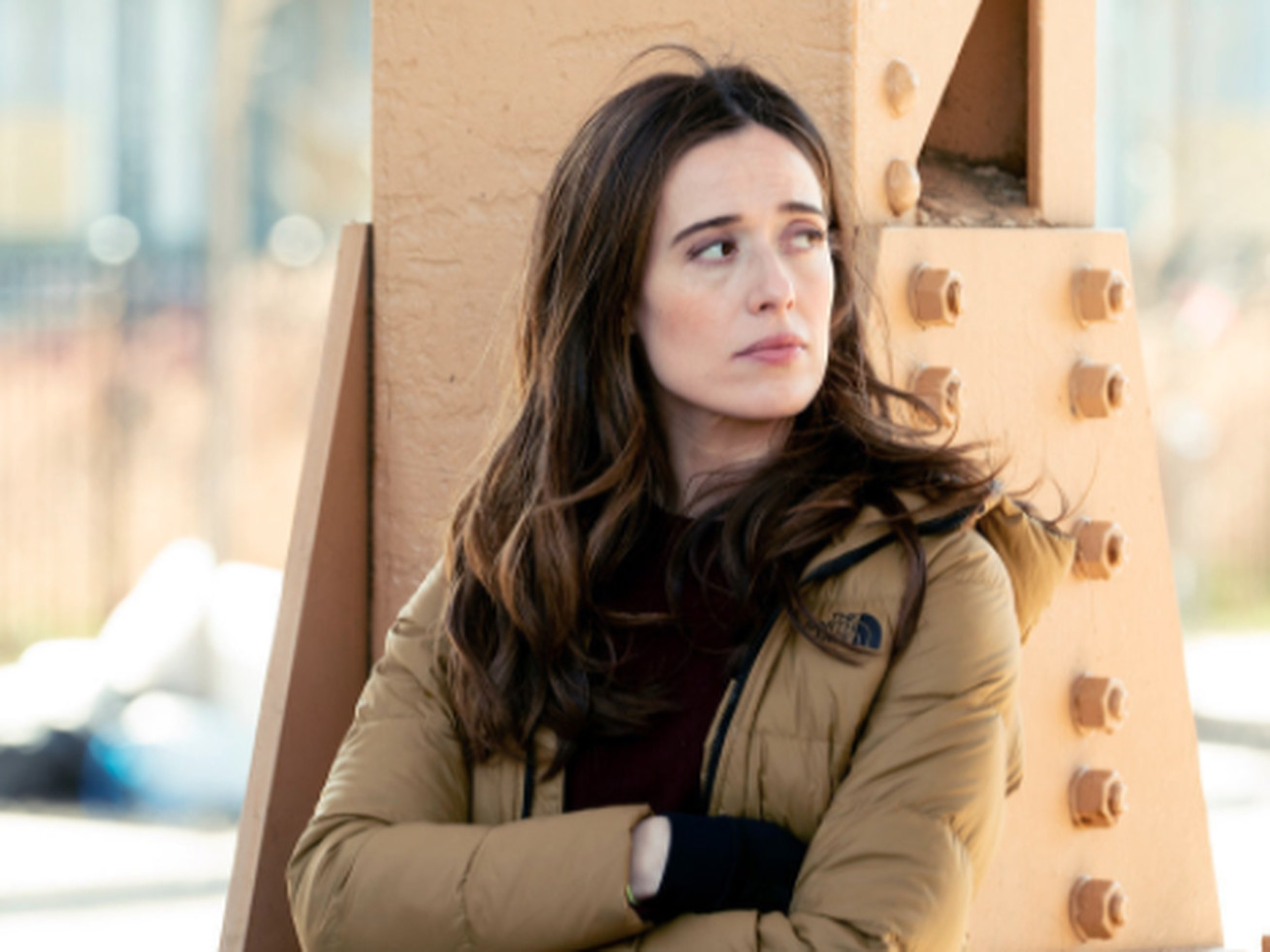
“Chicago P.D.” cast member Marina Squerciati says the show continues to make nuanced changes in storylines. | Lori Allen/NBC
Squerciati, a mother in real life, says: ‘Sometimes, I feel like I’m doing everything kind of well — I’m not killing it; I’m doing OK.’
As one door closes, another opens, and, in the case of Marina Squerciati’s “Chicago P.D.” character, she wrestles with the reasons why she takes on motherhood post-miscarriage.
Amid season eight of the popular NBC series, which airs Wednesdays at 9 p.m., a young girl whose parents are murdered ends up in government care and is taken in by Officer Kim Burgess. On this week’s episode, she decides whether to adopt the child.
In the previous season, Burgess suffered a miscarriage, of a child fathered by her ex-fiance, Adam Ruzek, after she was beaten while trying to save a young woman.
“Adam says to me: ‘Are you doing this for her or for you?’ And I think that speaks to good acts in general.” Squerciati said in an interview. “I think that unpacks something for her and I think ultimately she decided she was doing it for both of them, right? Saving both of them, so I don’t think it would have happened if she hadn’t had the miscarriage.
“But I think it’s a good thing; she’s a girl who has been traumatized — or lost her family. … I’m a woman who’s single and who’s lost a child, and we come together and I think that’s a good thing, ultimately.”
Squerciati, who in real life is the mother of a young girl, says her storyline shows why parenting — whether a person is the birth parent or not — isn’t a zero-sum endeavor.
“It’s great as an actor because you don’t have all the tools at the beginning of an episode, right? And you’re unpacking your box and learning how to deal with each thing as it comes up,” said Squerciati. “… Also as a working mom myself, it’s this constant hustle of trying to do your job while trying to take care of your kid, and earn a living at the same time. Sometimes, I feel like I’m doing everything kind of well — I’m not killing it [laughs]; I’m doing OK.”
Matt Dinerstein/NBCMarina Squerciati (left) with “Chicago P.D.” cast members Jason Beghe (from left), Patrick John Flueger (background), and Tracy Spiridakos.
And Squerciati says the show continues to make nuanced changes in storylines. “Chicago P.D.,” critics say, is one of TV’s main purveyors of “copaganda,” a tendency of TV series to depict police officers solely as heroes.
LaRoyce Hawkins, “P.D.’s” lone Black series regular, has been vocal in making sure storylines reflect real life, Squerciati says, in speaking with cast members and producers.
“I think that you can’t start a cop show — a Chicago cop show in a post-George Floyd world — without acknowledging it. I feel like that would be socially irresponsible,” said Squerciati. “I think that the writers giving LaRoyce this voice in order to speak to that part of the unrest is really important. Now, I don’t think the show does everything perfectly because it’s a television show, but I think addressing reform is really important.”

:no_upscale()/cdn.vox-cdn.com/uploads/chorus_asset/file/22490106/Chicken_Rice_Credit_Boon_Tong_Kee.jpeg)
:no_upscale()/cdn.vox-cdn.com/uploads/chorus_asset/file/22490088/Claypot_Stirring__1__credit_Geylang.jpeg)
:no_upscale()/cdn.vox-cdn.com/uploads/chorus_asset/file/22490096/Braised_Beef_Noodle_Soup_1__credit_Ten_Sun.jpeg)
:no_upscale()/cdn.vox-cdn.com/uploads/chorus_asset/file/22490081/Streetbird___Crispy_Bird_Sandwich_Credit_Samuelsson_Group.jpeg)
:no_upscale()/cdn.vox-cdn.com/uploads/chorus_asset/file/22490108/Blood_Bros_BBQ___Platter__Credit_White_Beard_Photography.jpeg)


/cdn.vox-cdn.com/uploads/chorus_asset/file/22488851/merlin_83707132.jpg)